Christchurch (New Zealand)
| WARNING: The outbreak of the infectious COVID-19 (see coronary virus pandemic) caused by SARS-CoV-2 virus, also known as coronavirus, has led to worldwide travel restrictions. It is therefore very important to consult the opinions of the official bodies of Belgium and the Netherlands on a frequent basis. These travel restrictions may include restrictions on entry, the closure of hotels and restaurants, quarantine measures, the right to be on the streets for no reason and more, and may be introduced with immediate effect. Of course, in your own interests and those of others, you should follow instructions from the government immediately and promptly. |
Christchurch is a city in New Zealand.
Info
Christchurch is the capital of New Zealand's Southern Island. It is a very English-disrupted city, but it also speaks to the Dutch, because most of the city is as close as the Netherlands! The River Avon (not named after the river at Shakespeare's birthplace, but to a small river in Scotland) is flowing through the city. In Zomers, you can make boat trips on the river in a kind of gondel (Punting on the Avon). There is also a large, free-access botanical garden near the center, adjacent to the former campus at Canterbury University (currently used as the Arts Center).
Arrive
By airplane
Christchurch's international airport is located in Harewood, some 8 km from the city center. Since the distance Christchurch - South Pole is around 6 000 km, the airport is used in summer (October-March) as a basis for supplying research stations at Antarctica with Hercules transport aircraft. As a pleasant side-effect, this means that the runways are so long that all the large body vehicles (up to the new A-380) can start and land without difficulty. There are therefore direct flights between Christchurch and Singapore and Christchurch and most destinations in Australia.
Per boat
By car
Takes into account the fact that roads designated as highway are comparable to provincial roads in the Netherlands. The maximum authorized speed is 100 km/h. Since many trucks are on the road, particularly between Christchurch and Dunedin and between Christchurch and Picton, overtaking can be dangerous. On some sections, the SH1 (the main North-South route) is 3-bans with 1 direction 2 lanes each. When you plan your journey, take into account the fact that 300 to 400 km per day is the maximum achievable. The road through the mountains is very boggy, and in some places it is very steep, and so you can be happy to drive more than 60 km/h. In the immediate vicinity of Christchurch (Canterbury Plains), the landscape is quite flat and can usually be quite advanced. Rack on the following driving times:
| From | To (via) | Travel time in hours |
|---|---|---|
| Christchurch | Picton | 4 |
| Christchurch | Dunedin | 4 |
| Christchurch | Invercargill | 7 to 8 |
| Christchurch | Westport (Lewis Pass) | 5 to 6 |
| Christchurch | Hokitika (Arthurs Pass) | 4 |
| Christchurch | Franz Josef Glacier | 6 à 7 |
| Christchurch | Queenstown | 7 |
By train
Christchurch is the starting point for two of the three remaining rail routes on the south island where passenger trains are still running. The TranzAlpin drives daily from Christchurch to Greymouth (on the west coast), driving through the southern Alps through a spectacular route through Arthurs Pass. Greymouth is connected to InterCity buses to Fox Glacier and to Westport and Nelson. The train is about half an hour at noon in Greymouth and then goes back to Christchurch where it arrives at the end of the afternoon. The boat train leaves Christchurch to Picton every morning and connects to the early afternoon of the Interislander to Wellington. About an hour after arriving in Picton, this train is back to Christchurch, where it arrives at the beginning of the evening.
Per bus
InterCity [1] has daily services to Picton, Dunedin, Invercargill, Queenstown and Mt.Cook. These buses run from Ritchies Travel, 123 Worchester Street.
Other companies provide services including Hanmer Springs [2] and Akaroa.
The urban transport company [3] of Christchurch has frequent connections between Christchurch Center (near Cathedral Square) and suburbs, including frequent bus services to and from the airport.
Round trips
The city center is on foot to be explored very well. In addition, the Christchurch Tramway [4] is running through the city and is stopping at the main sites. For destinations a little further from the center, you can travel by city bus [5]. Most city buses stop in the center on Colombo Street between Hereford Street and Cashel Street or in Worchester Street near Cathedral Square.
The urban transport company [6] also operates a frequent bus service to the airport (line 10 or line 29). You should also take these lines if you want to go to the International Antarctic Center [7].
Preview
Cathedral Square [8]. The Heart of Christchurch. In the summer months, there's a market here on working days, and if you're lucky, around 1:00 the Wizzard will appear on the speakers corner right in front of the cathedral. The cathedral tower is open, and you can climb the staircase for a fee to one of the highest avenues from which you have a beautiful view of the city and its surroundings.
The International Antarctic Center [9]. This center of information on the Antarctic is next to Christchurch airport (from the terminals, follow blue penguin tracks, approx. 10 min walking). You can experience the sensation of a snowstorm on Antarctica, and you can make a ride in a crawler vehicle (a so-called Haglund) that carries out the transport on Antarctica. These vehicles travel over a specially constructed circuit around the exhibition center.
Arts Center [10] on Worchester Street/Rolleston Avenue. This artist's location is located at the former campus of Canterbury University. It's a maze of stores, galleries and restaurants. In the summer at weekends there are all kinds of manifestations on the courtyards.
Botanic Gardens, the former Hortus Botanicus at Canterbury University, is opposite the Arts Center at Rolleston Avenue. The Hortus is free of charge and forms part of Hagley Park, the great park of Christchurch.
New Regent Street, a shopping strip in the Spanish missile style
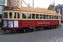
Christchurch Tramway [11] , in the early 1990s, a tramline was built specifically for tourists to circulate around the city along the main attractions. The trams leave Cathedral Square and drive through Worchester Street - Rolleston Avenue - Armagh Street - New Regent Street - Worchester Street - Cathedral Square.
Doing
Haglund Ride at the International Antarctic Center: Take a ride with a Haglund track vehicle as used on Antarctica. Around the Antarctic Center, a special circuit has been set up to demonstrate the potential of these vehicles (steep wall, amphibia, rough terrain).
Christchurch Gondola [12] - Gondellift to hill with a beautiful view of Christchurch.
Learning
Work
Buy
The main shopping streets are: High Street between Cathedral Square and Cashel Street; Cashel Street between High Street and Oxford Terrace; Worcester Street between Cathedral Square and Oxford Terrace; Colombo Street between Armagh Street and Lichfield Street, New Regent Street and Manchester Street between Armagh Street and Lichfield Street.
Eat
Budget
- The Oxford on Avon - Colombo Street/Oxford Terrace. On the top floor of this pub is an "all you can eat" restaurant where you can eat some NZD 25, p.p. excellent food.
Average
Duration
Go To
Overnight
Budget
Christchurch has some 10 Backpacker hostels. A.k.a. Eric Foley's hostel [13] at Kilmore Street, next to the fire station. Eric is one of the founders of the BBH New Zealand [14] listing.
Average
"Motel Row" is another name for Bealy Avenue. And along this busy road, you find a lot of motels. This row goes on, out of town, along Papanui Road.
Another part of the city with many motels is the area around the train station in Addington, mainly along Blenheim Road and Riccarton Road.
Duration
The big, expensive hotel chains all have their hotels in the center around Cathedral Square.
Security
Like most cities in New Zealand, Christchurch is also extremely safe by Western standards. Take into account the normal security measures as you would do in Amsterdam or Brussels.
Earthquakes 4 September 2010 and 22 February 2011
On Saturday, 4 September 2010, at 5:30 a.m. local time, a major earthquake (7.4 on the Richter scale) occurred with the epicenter near Darfield, around 40 km west of Christchurch. There was a lot of material damage (around 20%). 2/3 of the city's homes suffered damage to a greater or lesser extent), but fortunately there were no deaths. The proper organization of rescue services and first aid prevented all kinds of dangerous situations. A few days after the earthquake, the city was again "rotating", although the recovery and rebuilding work will take a long time. As if this were not bad enough, on February 22, 2011, around lunchtime, the earth began to vibrate again, this time by 6.3 on the Richter scale, but the epicenter was closer to the city center (in the middle of the port of Lyttleton) and less below the surface than it was at the earthquake of September 4, 2010. Consequent: the already heavily damaged city center was now completely in ruins and the cathedral, which survived the earthquake in September, almost completely collapsed. There were also about 100 deaths.
Contact
Daily life
Rondom
- Lyttleton is the port of Christchurch. From the city, this picturesque town can be reached with city bus line 28 or line 35 from Cathedral Square/City Exchange.
- Akaroa [15] is the only survivor of a French attempt to colonize New Zealand. The village is about 1 hour running from Christchurch.
- Hanmer Springs [16] is comparable to Rotorua in the North Peninsula, in that this village consists exclusively of a large group of hotels and motels around hot water sources.
| This is a useful article. It contains information on how to arrive, and on the main attractions, night parks and hotels. An adventurous person could use this article, but just dive in and expand it! |